

Tech Chat | Mastering Road Stakeout with SingularPad – Part 1
In the realm of civil engineering and construction, precision is the bedrock of success. To ensure the creation of safe and functional roads, the practice of "road stakeout" takes center stage. In this blog, we will introduce you to the process of initiating road stakeout tasks using the SingularPad field software.
Step 1: Acquiring Road Files
The journey into road stakeout commences with the acquisition of road design data. There are two principal methods for obtaining this indispensable information:
1. Importing a Road File
Streamline your workflow by seamlessly importing existing road design files, ensuring your project aligns flawlessly with approved specifications. In SingularPad software, navigate to Survey >> Stake Road, where you can effortlessly import road files, supporting common formats like XML, DXF, and more.

But what are XML files? They are pivotal components of the road design and stakeout process. XML, or Extensible Markup Language, is a standardized format for exchanging structured data. In the context of road design, XML files house vital information about alignment, profiles, cross-sections, and beyond.
XML files serve as the linchpin for smooth data exchange among various software applications involved in road design and construction. They ensure that you wield accurate design data, elevating the precision of your stakeout tasks.
2. Designing a Road File
For those starting from scratch, SingularPad offers the freedom to craft a new road design, granting you absolute control over the project. Click "New" to embark on your road file design journey. Here, you can meticulously edit parameters such as broken stations, centerlines, vertical profiles, standard cross-sections, and slopes.

2.1 Broken Stations
Broken stations denote instances of discontinuity in pile numbers due to local alterations or section measurements. There are two primary scenarios: one where the front stake surpasses the back stake, and the other where it falls short.
Broken stations come in two flavors:
- Long Chains: When the front pile number exceeds the back pile number (e.g., K112+943.305 = K112+900.001), resulting in duplicate piles. Here, we have a "long chain," with the distance between two long chains equaling the pile difference, typically 43.304 meters.
- Short Chains: When the front pile is smaller than the back pile (e.g., K115+309.227 = K115+320.001), causing a gap in the stake. This is known as a "short chain," with the distance between two short chains mirroring the pile difference, typically 10.774 meters.
In summary, repeated pile numbers constitute a long chain, while broken pile numbers indicate a short chain. SingularPad seamlessly handles both long and short chains and accommodates multiple broken stations concurrently. We recommend inputting broken stations first to avoid later alterations that could affect other parameters. These entries should be made as real numbers. For instance:
- Before the break: K1+234.000 = K1+238.000. Enter 1234 for the mileage before the break and 1238 for the mileage after.
- Before the break: K112+943.305 = K112+900.001. Enter 112943.305 for the mileage before the break and 112900.001 for the mileage after.

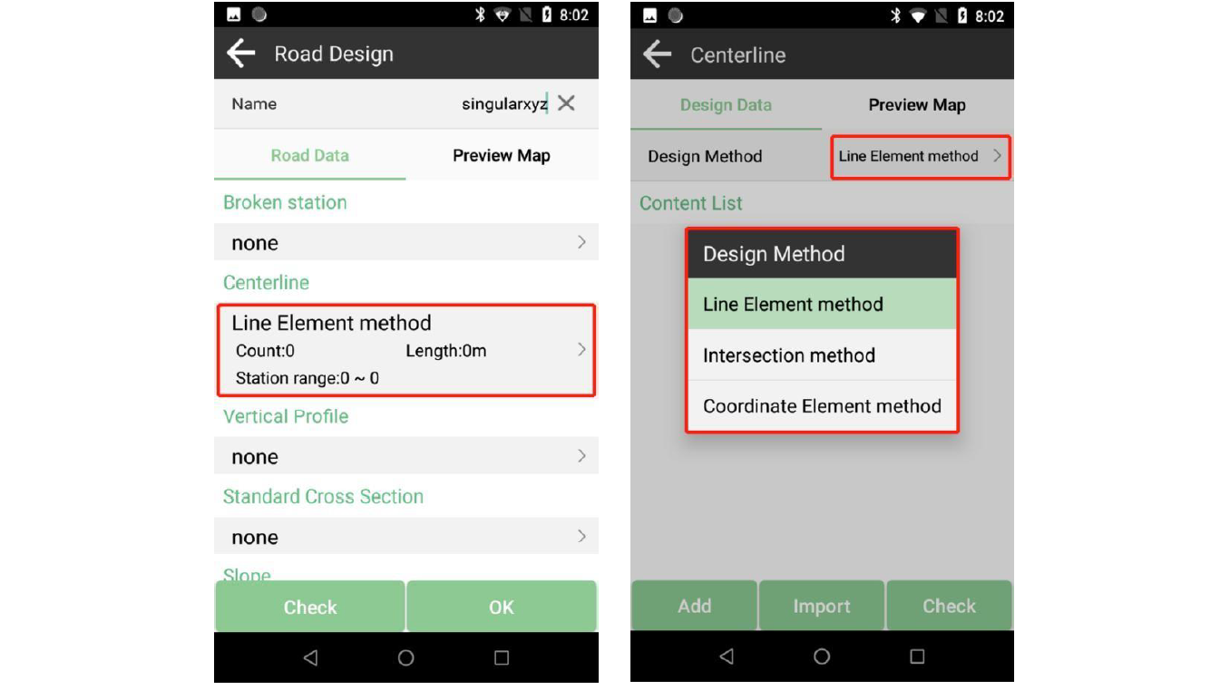
2.2 Centerlines
SingularPad offers three distinct methods for defining road alignment: the line element method, the intersection method, and the coordinate element method.
2.2.1 Intersection Method
The intersection method hinges on points of intersection, primarily utilizing point coordinates to establish alignment. To execute this method:
- Begin by tapping "Add" to input parameters for the starting point and save it.

- Proceed to input parameters for each station one by one, culminating with the end point.

- The centerline interface provides comprehensive details and a preview map for your review.
- Utilize the "Check" feature to scrutinize coordinates using three methods for stakeout: by station number, distance, or input station and offset. Verify three or four coordinates of the stations to ensure no erroneous data entry.

2.2.2 Line Element Method
The line element method is a widely preferred approach that employs element parameters such as line length, azimuth, spiral, and curve to define alignment. To employ this method:
- Choose the line element method and add the starting station.

- Subsequently, input parameters for each feature one by one. Typically, after finishing one feature and clicking "Next," the sequence cycles through line, spiral, curve, and spiral, although you can adjust this order as needed.

- Important
tip: In most cases, the starting radius of the first spiral is infinite, while the ending radius corresponds to the radius of the next curve. The starting radius of the first spiral aligns with the radius of the previous curve, with the ending radius designated as infinite.
- You can review and edit these parameters within the centerline interface.

2.2.3 Coordinate Element Method
The coordinate element method is suitable when the road comprises solely lines and curves.

- You can review and edit these parameters within the centerline interface. Design roads by importing road files, selecting from a plethora of available formats, or create a new design.

2.3 Vertical Profile
Vertical profiles encompass grade breaks and offer two distinct methods. You can choose to input elevation data at each station and review.

2.4 Standard Cross Section
Standard cross-sections can be imported and customized within SingularPad. Each cross section comprises left and right sections.

- Typically, editing begins with the left section, where you input parameters such as width, slope, and elevation data. Click "OK" to save or "Next" to proceed to the next section. All measurements are in meters.

- If the right section mirrors the left, simply select "Symmetry" in the right section interface to automatically replicate the right section. Otherwise, manually input the right section data.

- If ultra-height and ultra-width data entry is required, tap the cross-section data already entered in the content list and input the necessary information.

2.5 Slope Data
To complete your road design, enter cut or fill data for each station as needed.

With your meticulously crafted road files, you are now poised to delve deeper into the road stakeout process. In the upcoming chapter, we will focus on setting up for success and configuring road data for your project.
Learn more about SingularPad software and SingularXYZ RTK devices
https://www.singularxyz.com/SingularPad.html
https://www.singularxyz.com/X1.html


